Dubai Telegraph - Hurricane Erin intensifies to category 3 storm as it nears Caribbean

EUR -
AED 4.233941
AFN 75.510993
ALL 92.895553
AMD 421.791987
ANG 2.063402
AOA 1057.189164
ARS 1719.666632
AUD 1.633631
AWG 2.076622
AZN 1.959145
BAM 1.956128
BBD 2.323889
BDT 141.623711
BGN 1.955703
BHD 0.434721
BIF 3456.328303
BMD 1.152878
BND 1.47676
BOB 13.528265
BRL 5.999462
BSD 1.153793
BTN 110.063427
BWP 15.531735
BYN 3.470081
BYR 22596.409184
BZD 2.320489
CAD 1.606478
CDF 2620.492112
CHF 0.938214
CLF 0.026788
CLP 1054.30355
CNY 7.774089
CNH 7.776231
COP 3603.539297
CRC 518.09573
CUC 1.152878
CUP 30.551268
CVE 110.806918
CZK 24.233264
DJF 205.4644
DKK 7.476299
DOP 67.45877
DZD 153.386928
EGP 57.851652
ERN 17.29317
ETB 186.639867
FJD 2.552414
FKP 0.853362
GBP 0.85487
GEL 3.008956
GGP 0.853362
GHS 12.768161
GIP 0.853362
GMD 84.738875
GNF 10116.504447
GTQ 8.794844
GYD 241.394603
HKD 9.046743
HNL 30.932447
HRK 7.534174
HTG 150.916576
HUF 363.605759
IDR 20603.083088
ILS 3.415937
IMP 0.853362
INR 109.984736
IQD 1511.453054
IRR 1584731.718527
ISK 142.207078
JEP 0.853362
JMD 182.542145
JOD 0.817414
JPY 183.88752
KES 149.274754
KGS 100.818973
KHR 4666.273472
KMF 492.279074
KPW 1037.590556
KRW 1635.495083
KWD 0.356032
KYD 0.961561
KZT 536.939897
LAK 26014.692354
LBP 103240.226395
LKR 384.614394
LRD 209.420469
LSL 18.680483
LTL 3.404149
LVL 0.697364
LYD 7.332315
MAD 10.731566
MDL 20.029267
MGA 4969.961419
MKD 61.535302
MMK 2420.866319
MNT 4148.019682
MOP 9.325561
MRU 46.236106
MUR 54.357961
MVR 17.812287
MWK 2001.396438
MXN 19.638581
MYR 4.711238
MZN 73.680874
NAD 18.674918
NGN 1568.628945
NIO 42.457108
NOK 10.969171
NPR 176.104539
NZD 1.970816
OMR 0.443284
PAB 1.153793
PEN 3.893452
PGK 5.105855
PHP 70.757907
PKR 320.26412
PLN 4.310783
PYG 6886.152908
QAR 4.19073
RON 5.237063
RSD 117.308956
RUB 95.777274
RWF 1699.599296
SAR 4.315353
SBD 9.297893
SCR 15.961219
SDG 692.298626
SEK 11.025584
SGD 1.475804
SHP 0.854128
SLE 28.302889
SLL 24175.27474
SOS 659.416122
SRD 43.489443
STD 23862.247354
STN 24.504103
SVC 10.09569
SYP 14989.719902
SZL 18.618117
THB 38.241227
TJS 10.661085
TMT 4.046602
TND 3.383203
TOP 2.775854
TRY 55.141591
TTD 7.82431
TWD 37.048863
TZS 3049.94225
UAH 51.577077
UGX 4283.791525
USD 1.152878
UYU 46.18767
UZS 13782.307491
VES 882.411276
VND 30061.294361
VUV 136.725139
WST 3.148255
XAF 656.072533
XAG 0.01788
XAU 0.000265
XCD 3.11571
XCG 2.079448
XDR 0.815958
XOF 656.066841
XPF 119.331742
YER 273.405547
ZAR 18.673799
ZMK 10377.282978
ZMW 21.691632
ZWL 371.226252
  • RYCEF

    0.1700

    20.71

    +0.82%

  • CMSC

    0.0250

    21.475

    +0.12%

  • RBGPF

    0.0000

    72.16

    0%

  • NGG

    0.5200

    81.2

    +0.64%

  • GSK

    0.1500

    50.45

    +0.3%

  • BCE

    0.1900

    23.32

    +0.81%

  • RIO

    -3.0200

    98.2

    -3.08%

  • AZN

    -1.2600

    157.24

    -0.8%

  • BTI

    1.5100

    57.35

    +2.63%

  • BP

    -0.1000

    42.83

    -0.23%

  • VOD

    0.1300

    16.22

    +0.8%

  • CMSD

    0.0000

    21.59

    0%

  • BCC

    -0.1200

    84.13

    -0.14%

  • JRI

    -0.0300

    12.68

    -0.24%

  • RELX

    0.1200

    34.67

    +0.35%

Hurricane Erin intensifies to category 3 storm as it nears Caribbean
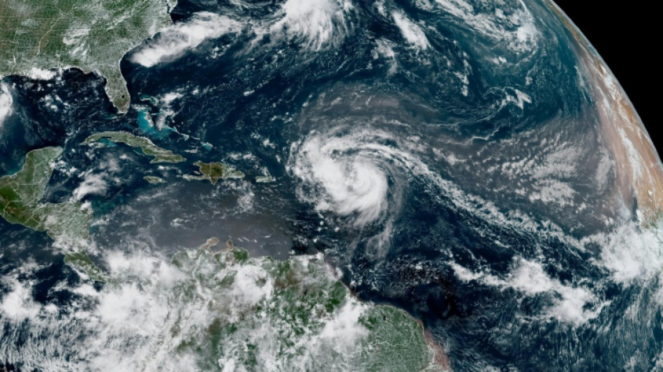
Hurricane Erin intensifies to category 3 storm as it nears Caribbean / Photo: Handout - NOAA/AFP

Hurricane Erin intensifies to category 3 storm as it nears Caribbean

Hurricane Erin strengthened rapidly to a Category 3 storm early Saturday as it churned towards the Caribbean, with a warning issued that flash floods and landslides were possible.

Text size:

The US National Hurricane Center (NHC) said the storm's maximum sustained winds had increased to 120 miles (193 kilometers) per hour by 0900 GMT, making it a major hurricane.

Erin, the first hurricane of the Atlantic season this year, was located about 170 miles (275 kilometers) northeast of Anguilla in the northern Leeward Islands, an area that includes the US and British Virgin Islands.

"Continued rapid strengthening is expected, and Erin is forecast to become a Category 4 hurricane later today," the NHC said in its latest bulletin on Saturday.

Tropical storm watches remained in effect for St. Martin, St. Barthelmy and Sint Maarten, with tropical storm conditions possible within 12 hours.

The NHC discontinued a tropical storm watch for Anguilla as the storm moved away from the island.

The hurricane's center is expected to move over the weekend just north of the northern Leeward Islands, the Virgin Islands and Puerto Rico.

The storm could drench the islands with as much as six inches (15 centimeters) of rain in isolated areas, the NHC said.

It also warned of "locally considerable flash and urban flooding, along with landslides or mudslides".

Swells generated by Erin will affect portions of the northern Leeward Islands, Virgin Islands, Puerto Rico, Hispaniola and the Turks and Caicos Islands through the weekend.

Those swells will spread to the Bahamas, Bermuda and the US East Coast early next week, creating "life-threatening surf and rip currents," the NHC said.

The hurricane is forecast to turn northward by late Sunday. While meteorologists have expressed confidence that Erin will remain well off the US coastline, they said the storm could still cause dangerous waves and erosion in places such as North Carolina.

The Atlantic hurricane season, which runs from June until late November, is expected to be more intense than normal, US meteorologists predict.

Several powerful storms wreaked havoc in the region last year, including Hurricane Helene, which killed more than 200 people in the southeastern United States.

The National Oceanic and Atmospheric Administration -- which operates the NHC -- has been subject to budget cuts and layoffs as part of President Donald Trump's plans to greatly reduce the size of the federal bureaucracy, leading to fears of lapses in storm forecasting.

Climate change -- namely, rising sea temperatures caused by the burning of fossil fuels -- has increased both the possibility of the development of more intense storms, and their more rapid intensification, scientists say.

X.Wong--DT